

University Presentation Showcase: Faculty Poster Gallery
Preview
Creation Date
Spring 2017
Department
Geosciences
Abstract
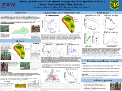
Ephemeral wetlands on Appalachian ridge tops in the Daniel Boone National Forest, Kentucky are hydrologically connected to shallow perched groundwater. Although these perched groundwater-wetland systems have been shown to support native vegetation and amphibians, the physical controls and hydrologic connectivity are rarely studied due to geographic isolation and sparse occurrence. In this research we determined the hydrologic connectivity of a perched groundwater-wetland system in Daniel Boone National Forest by (1) Mapping wetland morphology, (2) Monitoring groundwater and surface water, and (3) Quantifying groundwater inputs and outputs. First, the ~2500 m2 watershed area containing the perched groundwater-wetland system was mapped using an optical transit and GPS unit to create a point cloud. The point cloud data were then interpolated to create a surface map. Second, wells were installed in the perched groundwater and open water portion of the wetland to monitor groundwater and surface water levels. Aquifer properties were determined through core analysis and slug tests. Groundwater flow direction and magnitude were determined via groundwater head and Darcy’s law. Third, using surface maps and monitoring data, groundwater inputs and outputs were calculated. The recharge zone of the groundwater was determined to be the open water area of the wetland. Groundwater inputs were determined based on the temporal change in hydraulic gradient and open water area. The main groundwater output was evapotranspiration, which was measured via the White (1932) method. Estimates of both recharge and evapotranspiration of groundwater are of similar magnitude, indicating little groundwater outflow or deep recharge.
